
In an online conversation with Max he happened to notice, on a 1949 version of an OS map, the name “Hollowpark Rock”. Cross referencing with a modern version (not OL28 because, it seems Ordnance Survey think that area of the National Park is not important enough to be included), the rock had disappeared! Only one thing for it, a trip out to the land off the edge of the world!
The next morning, we had met up at Trenchford Reservoir and were heading off in the mizzle to rediscover this lost outcrop. But not without dropping in on a few old friends. First up, Trenchford Tor at SX 8028 8296. Max had found this one a few months ago, hidden on the edge of Trenchford Reservoir, just off the path. For want of an official name, Max named it appropriately.

As Max did the next outcrop we were to visit, and a new one for me. Little Trenchford Tor lies a stones throw from the main outcrop, at SX 8019 8304, and right beside the path. This is a small, but well formed pile with that moss cladding that I love!


Onwards, we picked our way along the tracks within the plantations to the road, where we turned left. not long before we had stepped, right, into the woods, making for Kennick Rocks at SX 8039 8378.

The emergence of bluebell leaves has accentuated the outcrops, revitalised the scene and it appears much larger than my first visit. In a few weeks this promises to be a riot of blue. A great find by Max.
Unable to follow the Kennick Reservoir private shoreline, we were forced along footpaths with little interest, until we reached Clampitt. We came across a plaque for a burial ground, which was used between 1674 and 1740.

It’s difficult to say where this burial ground is, apart from the plaque there is little evidence, and I read a suggestion that it may have been moved when Kennick Reservoir was built. If anyone reading this has information, please leave a comment.

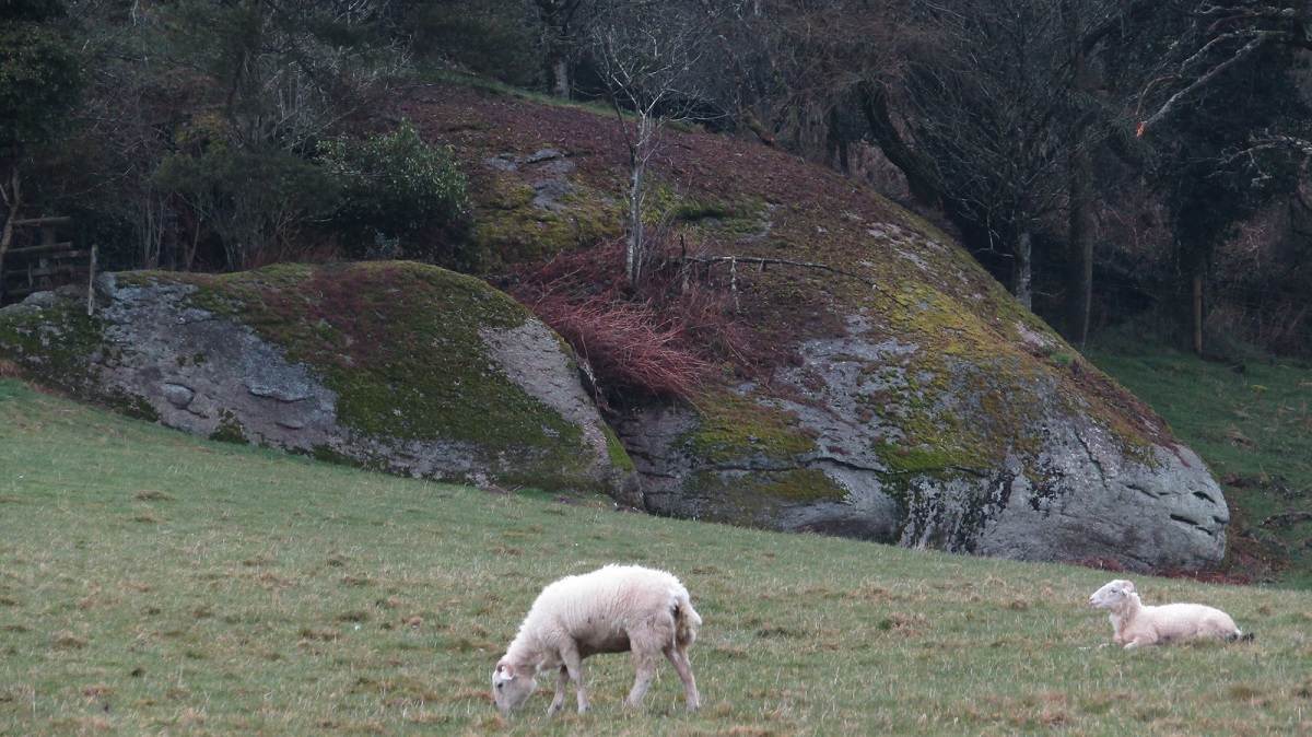
Passing some old farm buildings and dropping down to an old ford, I spied a locked gate where I calculated we may get our first view of Hollowpark Rock; we weren’t disappointed. We could see, on the other side of a field, a huge outcrop, whose omission by Ordnance Survey, defies belief!

I figured this distant view would be the best we would get of it, but we were still eager to reach it. The bridleway takes you away from the rock, into a pretty moorland scene on the edge of Kennick Reservoir.
I spotted, just above the brown bracken and flowering gorse, a small, modest outcrop. We left the bridleway, meandered up to it, avoiding the pain of gorse as best we could, to find a charming little granite shelf at SX 8055 8463. Once again, for want of a better tag, it has been named Laployd Rock after the plantation it resides.


From here, we found an unmarked path beside a wall which took us to a bridleway where we encountered the much anticipated Hollowpark Rock. From the path it has an odd mushroom shape which fails to express the extent of this rock and our first encounter from the gate earlier did prove to be the best vantage point.

We clambered to the top, where its size is more apparent. Its surface is home to many mosses and the odd patch of bluebell, making it a multicoloured outcrop and one that Ordnance Survey should be ashamed to have removed from their modern maps.

Conscious of time, with Max needing to get a bus in a couple of hours, I cut out a planned trip to Scatter Rock, and we followed muddy footpaths to visit Rowdon Rock before heading back.
Rowdon Rock, what a gem! Marked on maps but falling foul of the Ordnance Survey National Park boundary issues, it is a lesser known tor. Climbing up from Rookery Brook, you have no idea what awaits you until you are directly beneath it.


At SX 8122 8603, you will find an absolutely magnificent tor with small caves, a narrow avenue, and large granite stacks in a setting with the feel of a tropical jungle. We were short of time but it deserves to be clambered over and explored thoroughly. Max was already planning his next visit!

Now for the long walk back, up beside Rookery Brook, then along a succession of poorly maintained flooded paths and gates, which made the road walk welcome. as we passed down, I spotted, to the east, an area of plantation near Blackingstone had been felled revealing a huge altar of granite. Too late to divert to today, but one for the future. I estimate this to be at SX 7927 8512.

The road walk back was long but we kept a relatively good pace, but not quick enough for Max to get to his bus at Slade Cross, so I dropped him off in Bovey Tracey. Travelling back home up the A382, his bus passed, heading for town, and I was assured he didn’t have long to wait.