
The following blog post is the culmination of two consecutive weekends on Blackadon Down. I felt the wealth of granite found on my solo visit merited a return with Tim Jenkinson, to verify the outcrops I had found. Also present, my friend Matthew King had the chance to experience these previously undocumented tors.
Parked up in Leusdon, we were soon on Blackadon Down, rising to the first outcrop of the trip, Blackadon Tor. This tor sits at the highest height of the down, and from the top you have views north up the East Webburn and the Hameldown Range. This one is documented, marked on Ordnance Survey maps. I should mention that, apart from this tor and Logwell Rock, the rest of the outcrops visited were without a label and so we endeavoured to name them appropriately, given their surroundings

Although known, Blackadon is not afforded the recognition it deserves. The main outcrop appears to be overgrown and unremarkable, but venture to its north side and you will encounter a more impressive face, and a few more outcrops that are missed.


The next tor on our walk is Logwell Rock. This is a favourite of mine, a bit of a struggle to reach through a tangle of bushes and low branches, but when you get there, it is a huge outcrop with a charming little avenue on its top.


Like Blackadon Tor, if you follow it down the hill, you will see that it is extensive and quite magnificent.
For us, the lower levels were visited later on our route, as we continued west to explore the woods. There was plenty of tor action going on here, the most striking being an outcrop at SX 7095 7342.

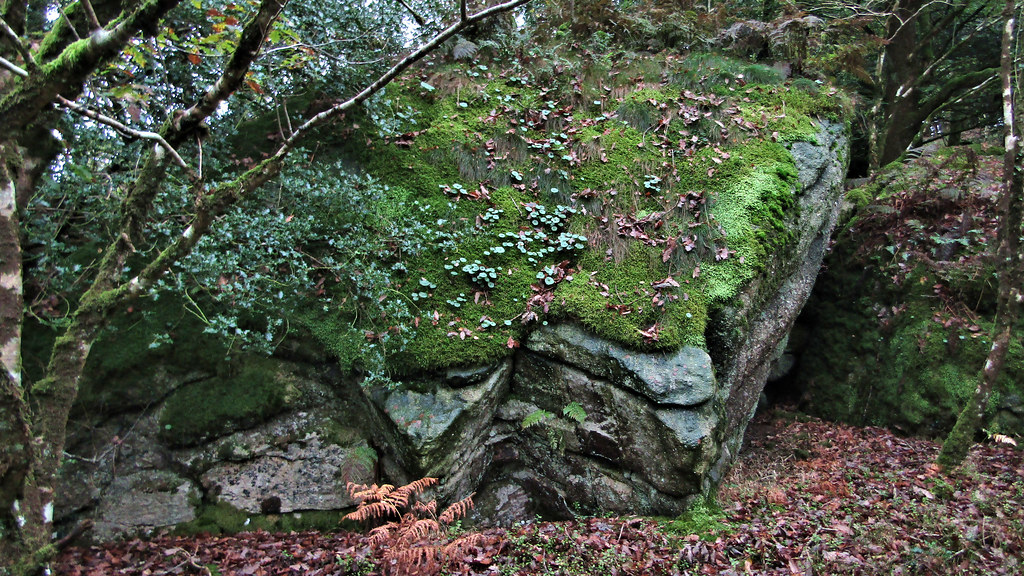
It is notable due to a large chunk of the outcrop appearing to have shifted, resting at an angle. It is now carpeted with a fluorescent moss that catches the eye in the dim light of the woods.

Whilst I had descended the first week, Tim had spotted something else and ascended. Good job he did because we came across a higher, much larger outcrop at SX 7092 7334. We agreed it should be named Leusdon Tor, as we could see the settlement through the trees and it was really quite close.
It was a magnificent pile and neglected by the public because it lies outside the Open Access area and there is no hint of it on any map I have seen.


Now we dropped down, halfway in height towards the East Webburn, which could be heard below. We reached lower outcrops of Leusdon Tor at SX 7091 7348. This was another fine set of exposed granite. I couldn’t believe my luck when I walked through here, I was enjoying myself even more now I had company to show these finds off to!


At SX 7126 7355, we encountered another outcrop. Looking at the map, we deduced it was part of Blackadon, so we called it Blackadon Lower Tor. It wasn’t huge, but it was certainly worth documenting.

As was the next. From above, there is little evidence as to the scale of this granite outcrop. I could see a section where the ground below me levelled out which I have learnt usually signifies a steep drop on the hidden side, and so decided to investigate. From the north, it is a vertical wall. Perched above the confluence of the East and West Webburn, at Lizwell Meet. For this reason, I called it Lizwell Rock, at SX 7129 7360.


We now made the perilous descent to the river. Tread very carefully, on these overgrown slopes, if you decide to visit.
At the confluence known as Lizwell Meet, the East and West Webburn join forces and continue their journey towards the Dart.

Crossing describes the scene in his book, Gems in a Granite Setting;
“The meeting place of these two rivers of Widecombe is one of those charming nooks that contrive to hide themselves from the gaze of the passer-by, and give scarcely a hint of their existence.”
William Crossing, Gems in a Granite Setting
One hundred and twelve years after Crossing’s book had been published, it is more of an effort to reach it. From the Open Access Land, a narrow path drops down from Blackadon Down, and hugs the left bank of the Webburn up to the confluence. From Cockingford, the route is simpler, but a permit is needed to enter the privately owned woodland. I would encourage you to visit. The path down from Blackadon Down, if you can find it, is a lot simpler than the route we had taken to reach this spot.

We followed the Webburn south on the poor Blackadon Down path, reaching an exposed rock face on its west side, that I called Webburn Rock, at SX 7151 7348. First thing to notice is that this is not granite, but metamorphic, and all the rocks south of here are this type.

The path begins to rise as the riverbank is poor, but there comes a fork where, choosing left, you return to the river. It is only a few hundred metres further, at SX 7172 7327, where the way is blocked by a huge outcrop on the bend. Tim suitably called it Town Wood Crags.


We had to return to the fork in the path, and continue up the hillside. The path is more discernible higher up, and if you follow it to its conclusion, you’ll be taken out onto the open downland. However, when studying some historical maps the previous week, I had spotted some outcrops marked on the slopes below.
The evidence of crags can be seen to your left as you descend, but it doesn’t impress until you have picked your way down to the river again. Getting here is difficult, with no path to follow. The river flows gently now, but evidence of its might can be seen at SX 7161 7316, where it has cut an impressive route through a high gully, which, for want of a name, I have called Webburn Gap.

From the south-western side, looking upstream, the rugged outcrop has an ancient face looking over the river; I call it “The Old Man of the Webburn”.

If you pass around the towering wall, stepping carefully along the edge of the river, you will see the tor rises high, a remarkable spot to discover and visit. There may be a way up the north-eastern side, but the undergrowth hides ankle traps and is fraught with danger, so best to return the way you came.


Heading further down the rivers course, the bank is littered with fallen trees that eventually bar the way. If you wished to continue further along the Webburn, the route must be picked up from the opposite bank. Sadly, the footbridge marked on old Ordnance Survey maps has gone, scaling the wooded hill is the only route out and our little expedition was at an end.
It’s a relatively short route, but the difficulty of the terrain makes it a strenuous one, so I would advise that you don’t tackle this one alone.