
An edited version of this article appeared in Dartmoor Magazine – Spring 2015.
This particular visit to the small but memorable tor known as Hurston Castle involves a fairly lengthy albeit circular route to and from Benett’s Cross car park at SX 680817 through parts of Grid Squares SX 6881, 6882 and 6883. The walk takes in not only the tor but also allows for the inspection of the ruins of the West Vitifer Mine and the splendid stone row atop Hurston Ridge.
The name of the tor in Bovey Country at SX 683834 first appears in Crossing’s ‘Guide to Dartmoor’ in 1909, but is better known from the 1912 edition reprinted for a new generation in 1993 by Peninsula Press. That said the reference is brief and is included in just two excursions on pages 248 and 475 where in the first the author simply describes a ‘ridge of rock’ on the eastern bank of the river ‘known as Hurston Castle’ and in the second that ‘Castle Hill’ lies above. From both descriptions it would have been difficult to locate the rocks. It is not until 1983, some seventy years later that we learn a little more about the area with the help of Eric Hemery in ‘High Dartmoor’ who on page 708 describes the Castle as a ‘beautiful tor’ explaining that ‘its foundation and ‘walls’ rise, castle like, precipitously from the steep falls of the river to its summit’. Whilst this is an altogether much fuller account one still has to follow Hemery’s lines very closely to work out exactly where the ‘Castle’ is positioned because as is the case with the many lesser known aspects of the moor, it is not shown either by name or contour on modern Ordnance Survey (OS) Maps.
Indeed it is not until the publication of Mike Brown’s Gazetteer of Dartmoor Names in 1996 that a National Grid Reference (NGR) is forthcoming, helping to pin point the location. I first visited the area in May 1998 and was impressed by the delightfully secluded group of rocks that are set on either side of the river. In recent months I was reminded of the Castle by fellow Dartmoor enthusiast Stephen Jenkins who quite rightly describes it as a lesser known tor, so in keeping with my interest in such rock piles I decided to revisit the area in April 2014 and remind myself once more of its beauty and solitude. I was not disappointed.
Starting from the small car park at Benett’s Cross I proceeded in a northerly direction over the B3212 and then across the open moor, towards the lower south west enclosure wall corner of Lakeland and then downhill to the ruins of the West Vitifer Mine set on the bank of what is still incorrectly marked as North Walla Brook on current OS 1:25000 maps at SX 679826 (it is actually Bovey River sometimes ‘Hurston Water’). Crossing expresses his concern over the use of the former name by the OS in his ‘Guide’ (pages 247-8) where he argues that ‘the name of North Walla Brook has been given in accordance with a certain view with regard to the forest boundary line’.
Whereas he accepts that the perambulators of 1240 drew the line ‘in longum Wallebroke’ from the north towards King’s Oven he goes on to explain that ‘we cannot be sure that the Bovey was intended and it is nowhere else spoken of as Walla Brook it is misleading to fasten that name upon it’. He continues to argue against the name further down the page and despite this it is interesting to see the error still repeated on today’s representations. Indeed Hemery (1983 page 710) refers to it as an ‘erroneous name’ used as an ‘attempt to settle a boundary dispute’ and asks for the OS to substitute the name for ‘River Bovey or Hurston Water’. Mike Brown concurs with both perceptions in his Gazetteer of Dartmoor Names.

Having pondered over this debate we now need to take care to cross the river and stop to view the old mid 19th Century mine walls here where there are several large boulders and small outcrops dotted on the banks above. Hemery (page 709) identifies amongst the ruins a stamping floor, a filled in wheel-pit with tail race and launder bank and a leat leading from the river’s left bank. Continuing along the western side of the river that soon starts to lose its definition in the mire below, the first glimpse of the eastern side of Hurston Castle is seen away to the north. The walking ground in places is sodden underfoot so care must be taken to avoid the waterlogged moor and head a little further to the west.
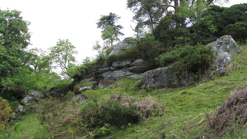
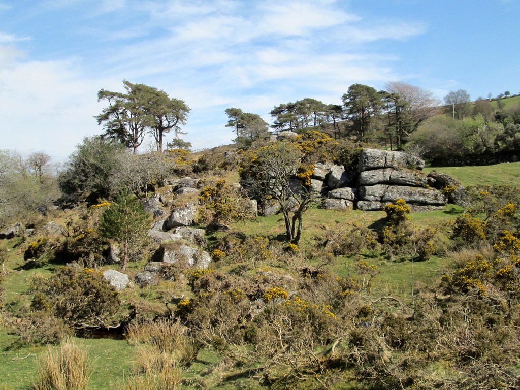
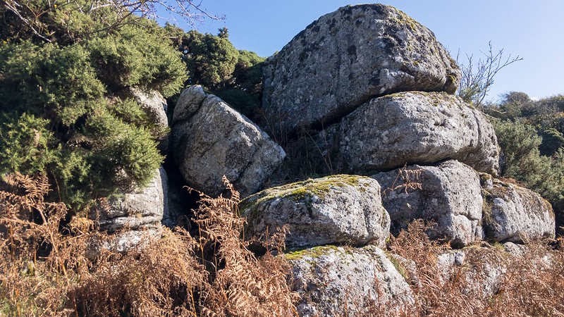
Making sure to loop well around the boggy ground and keeping on to soon pick up a small track that heads eastward, the rocks now come into view in all their splendour. The most distinctive part visible from here is the lower south eastern pile a fine outcrop with strong distinctive horizontal jointings in its face. Crossing the river at the small ford and climbing up on the grassy knoll the extent of the tor is plain to see, the highest part culminating in two large rocks. From here the boulders of the western bank are clearly visible and further to the north and east a very large rock face is part involved in an old wall leading down to the river. The valley sides steepen under the tor to the north in a most attractive way and the tall pines that Hemery describes in his account are still very much in evidence.
Altogether it is an exhilarating experience to stand among the rocks and listen to the water rush downhill. Disappointingly the map I had taken with me (1: 25000) was showing nothing of what I was looking at here with just the course of the river identified. On reflection there cannot be many tors on Dartmoor that have a river running through its rocks.
After exploring for a while and taking some field notes and photographs I re-crossed the river and re-joined the track and headed westward before turning south and walking across largely featureless moorland high above the river to the west, towards the impressive Hurston Ridge double stone row (SX 673824), the tall southern standing stone dotting the horizon on the approach. According to Paul Petit (1995) the row has 50 pairs of stones and is about 150 yards in length with a cairn at the higher end. The standing stone is given as 6 feet in height. All in all the row is a fine example and described by the author as ‘one of the best preserved of all the rows on Dartmoor’.

Leaving the stone row I then made my way to the south to pick up a well defined track taking me back towards the road and from there headed north back towards Benett’s Cross. Hurston Castle is rarely referred to in Dartmoor literature and only in relatively recent times have we become sure of its location thanks to a published NGR for the tor. I hope that this short article has given it a little more of the attention it deserves. Anyone wanting to learn more about the antiquities of Hurston Ridge is directed to an interesting article on the subject by Judith Cosford (1986) in Dartmoor Magazine number 3.
References
Brown, M. (1996) The Gazeteer of Dartmoor Names Forest Publishing Newton Abbot
Cosford, J. (1986) Mysteries of Hurston Ridge Dartmoor Magazine number 3 Summer
Crossing, W. (1912) Guide to Dartmoor 1990 edition Peninsula Press Newton Abbot
Hemery, E. (1983) High Dartmoor-land and people Robert Hale London
Petit, P. (1995) Prehistoric Dartmoor Forest Publishing Newton Abbot