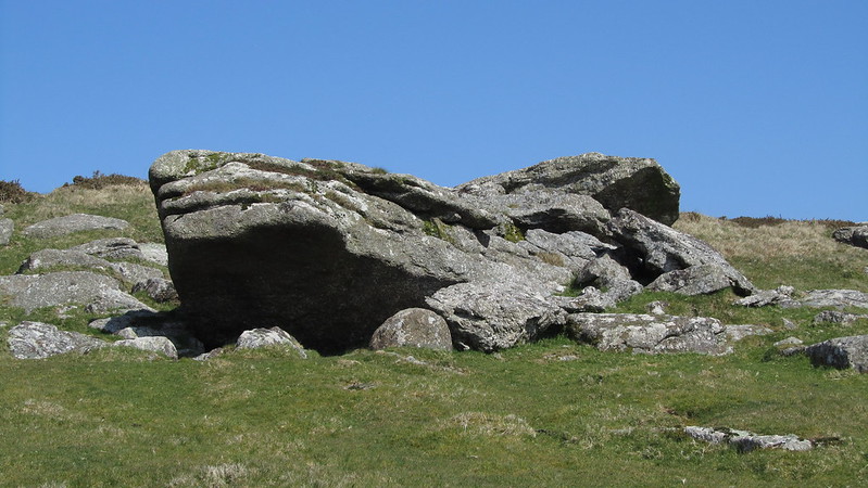
This is the large rock of so called Claret Tor overlooking the Lud Brook. Interestingly William Crossing writing in 1912 actually refers to both Claret Tor and Creber's Rock as separate entities. This can't be true as there are no other significant outcrops nearby. It's a mystery.
Indeed, Hemery does refer to them as the same, in High Dartmoor; "Above the left bank of the brook as its course begins to steepen is Claret Tor, or Creber Rock (1,125 feet), a picturesque, broken pile surrounded by springy, green turf."
In addition, a quick Google for information about this outcrop and you'll see there is a cider named after it.
Creber's Rock
The map above is not a navigation tool and we recommend that the grid reference shown below is used in conjunction with an Ordnance Survey map and that training in its use with a compass is advised.
Grid Ref:
SX 6645 5869
Height:
340m
Parish:
Ugborough
Tor Classification:
Valley Side
Access:
Public
Rock Type:
Granite
Credit:
Ordnance Survey William Crossing
Reference / Further Reading:
Ordnance Survey Maps Tim Jenkinson: Lesser Known Tors and Rocks of Dartmoor Eric Hemery: High Dartmoor
Please Support Us
We are proud to see the names of lesser-known tors are now being used more commonly on other websites and whilst this is to be encouraged we do request that, should you wish to use the information on this page, you provide a backlink to the website as reference, by copying the relevant address:
Please also consider a small donation to the upkeep of the site; any contribution goes toward the fees to keep the database online and any costs incurred when undertaking research such as subscriptions to online archives.