TORS OF DARTMOOR
a database of both lesser- & well-known rocks and outcrops
Lints TorNorth Lints Tor (Prowse), Lynch Tor (Rowe), The Sphinx 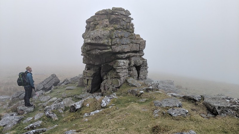 The North Moor is a wild place where numerous streams and rivers make swift progress through the dramatic landscape that is topped by lofty eminences. The valleys in this region are usually steep and quite beautiful and Lints Tor is situated in the heart of one of them - the West Okement. Although it sits well over 100 metres below High Willhays, the highest point on Dartmoor that is no more than 2 kilometres to the north, Lints Tor is a conspicuous landmark in this part of the valley sitting on its own moorland spur. It is so often viewed from the outcrops of Dinger Tor, Fordsland Ledge and Kitty Tor high above that it is difficult to forget that the tor is still almost 500 metres above sea level which makes it higher than any point on the South Moor with the exception of Ryder's Hill (515m). The tor is a granite bastion in its own right and as the visitor approaches they will note the distinctive outline of the summit pile, a massive core stack that has cast an enormous clitter to the north and west. The stack is often likened to 'The Great Sphinx of Giza' in Egypt on account of its appearance taking its form from certain vantage points. This feature, commonly referred to as just 'The Sphinx' is a limestone statue of a reclining sphinx, a mythical creature that is considered to be part of one of the wonders of the world. 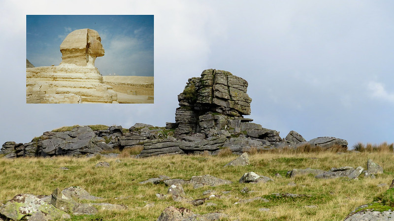 Lints Tor's crown is incredibly shattered but its outcrops continue northward where Black Tor stands sentinel above Black-a-Tor Copse on the right whilst the left valley side is considerably steeper topped only by the isolated rock of Steng-a-Tor. The scene is spectacular on a clear day. It is easy to see why so many Dartmoor authors wax lyrical about the tor, but it is Hemery (1983) who provides one of the most captivating accounts when he writes "Shaping the course of the brook, and peninsulated by it and the river, is the conical hill crowned by the rocks of Lints Tor (approx. 1,600 feet). Dwarfed though it is by the great hills forming the slopes of the W. Ockment Ravine, it makes a notable contribution to the wild scenery here and is, amusing to note, over a hundred feet higher than Hey Tor (Bovey)!" You will observe that the summit pile differs from the rest of the outcrops that stretch along a low ridge. Collingwood (2017) explains this unusual composition; "The coarser grained granite has the rounded edges and large feldspar crystals commonly associated with the tors. However, there is clearly fine grained granite intruded here too; the edges are much more angular and overall the rock is highly fractured." Outcrops are broken and strewn across the slopes which is indicative of a once giant tor at this location.  Accessing Lints Tor can be tricky for the inexperienced rambler since water bounds its west, north and east flanks that can prove hazardous after a wet period. It is therefore recommended that you approach from Dinger Tor on a grassy track that initially heads a little to the left of the tor before contouring around the head of Lints Tor Hollow. Or, after a dry spell, the route up the West Okement Valley from Meldon Reservoir is special, if a rather long walk, where you pass below and alongside the remnants of giant boulders from glacial times and the ancient Black-a-Tor Copse but this route, though, does necessitate the crossing of Lints Tor Brook before a steep climb up to the tor's rocks. Whatever route you choose, you will enjoy a journey that encapsulates some of the high moor's finest scenery. This is Dartmoor at its best. 
| ||||||||||||||||||||||||||||||