TORS OF DARTMOOR
a database of both lesser- & well-known rocks and outcrops
Narrow TorNarra Tor, Narrator 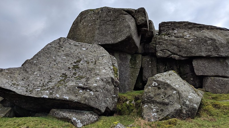 On page 120 of 'High Dartmoor', Hemery (1983) gives mention to a 'Narrow Tor' apparently marked as such on an 18th Century map as a northern spur of Sheeps Tor. However Hemery dismisses the likelihood of a tor in the vicinity, as he claims that the name like the nearby farm has 'faded away'. This is inspite of the fact that the ruin was still in evidence in the late 1960's.  Thankfully it is Terry Bound (1991) who resurrects our interest in this group, using the name 'Narrator' he is able to estimate a grid reference of SX 566 686, though admits to being unsure of the exact whereabouts of the tor. However, on the north slopes of Sheeps Tor Hill, there are two groups of large rocks that give rise to an extensive clitter on the crest of the steep descent towards Norsworthy Bridge. Here the lower pile is of most interest, forming a cluster of huge blocks the tor is seen to great advantage when viewed from below. The rocks' immense jointings form a series of of vertical caves, of which one is central to the tor's substance and deep enough to accommodate a standing person. On top of this a pile a small yet prominent logan type rock is perched. The entrance to the spectacular cave looks out impressively over Burrator Lake to the north and affords fine views of the three rock piles on the ascending ridge of Down Tor.  About 50 yards above this point the higher and more ruinous outcrop is scattered. Now forming little more than a jumble of boulders, the pile once played host to a giant spindly wooden crosses, during the Easter period of 1993. Clearly visible from the lower valley side at Norsworthy and Middleworth Lane, the cross served as a distinctive reminder of the religious festival for those that cared to glance up towards Sheeps Tor. On the summit of the ruined pile there remains the hole and supporting rock in which the cross's lower shaft was held, and it is believed to be a tradition still carried on to this day. 
| ||||||||||||||||||||||||||||||