TORS OF DARTMOOR
a database of both lesser- & well-known rocks and outcrops
ScobitorScobetor Rocks, Scobetorre, Scabtora, Scabatora 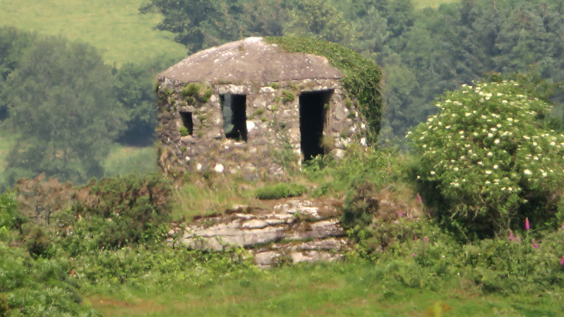 In his Guide to Dartmoor of 1909 William Crossing refers to Scobetor Rocks as being "within an enclosure near the house". Viewing from afar on Pudsham Down to the east as the tor sits on private land, it is obvious that there is also a curious circular domed building on the summit. Of Ash House proportions it sits above the short running southern rock face. Eric Hemery (p663) explains that the hut or tower as it is sometimes known was built in the First World War as a look out with what appears to be at least two windows and a door space, but this interpretation is now open to question following an onsite inspection and further assessment for May 2024. Built of granite rubble with a domed roof the now Grade II Listed structure has been subjected to a plethora of speculative purposes in the literature, a summary of which is supplied by Tim Sandles here.  The tor seems to be nothing more than a small rocky prominence above the farm of the same name at SX 723749 but there is certainly more hidden in the trees on the slopes below. Marked as Scobitor on modern Ordnance Survey (OS) maps, Terry Bound (1991) advises that in Domesday records the area was recorded as 'Scabtora'. Described as "magnificent" in the Western Morning News (WMN) of September 1888 upon the sale of the farm, the tor is set within the grounds a short way to the south west of the main buildings. Consensus of opinion is that the tower atop was built in 1868 (cited as that date in the HER Listing from 1955), so why did Crossing not mention it? The Listing reads: "Folly. Believed to date from 1868. Granite rubble with saucer-shaped, cement-rendered roof. Short round tower, possibly now reduced in height, standing on a natural outcrop of rock. It has a doorway and 5 windows of different sizes; 2 of the windows retain the remnants of wooden frames. Interior has a thick, round stone pillar in the centre, from which radiate heavy granite lintels carrying a granite roof." 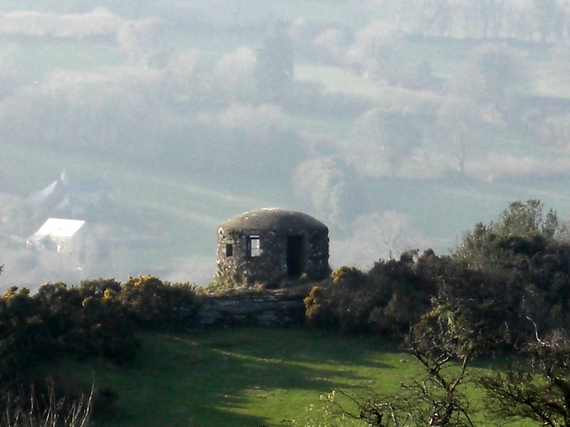 The idea of there being a bigger building here or at least an intended one is further explored by Headley & Meulenkamp in 1986 who write: "Scobitor Round House, above Widecombe in the Moor, is a circular one-roomed building with a slightly domed room and random fenestration. The really fascinating part of its construction is the presence of nine massive granite beams radiating from the top of the central pillar. They are far too heavy for the sole purpose of supporting the modest room; another reason has to be sought. It has been speculated that the house was intended as a beacon, but although the views across Dartmoor are spectacular, the only village it can be seen from is Widecombe. Perhaps the intention was to provide a firm base for another storey or two; certainly, the random pattern of windows seems to have been chosen to frame superlative views. A belvedere, then."  The May 2024 assessment facilitated by Max Piper with kind permission of the occupier confirms that there are 5 windows of varying sizes, a large doorway of over 6 foot in height and a domed roof supported by very large granite beams, perhaps indicative of a once larger structure here. Could it be possible that the original upper section of the tower was dismantled after damage in the storm of 1872? The variations in the size of windows might indeed date to a WWI alteration whereby views to important strategic points such as Pudsham Down, Hamel Down and Corndon were greatly improved. It is known that glider poles from WWII still survive on both Pudsham and Hamel Down.
| ||||||||||||||||||||||||||||||