TORS OF DARTMOOR
a database of both lesser- & well-known rocks and outcrops
Walkham Rocks
 This charming, albeit small but distinctive cluster of large rocks, can be found in a rather remote spot on the eastern side of the River Walkham at about a mile or so to the south of its source. In an area otherwise devoid of granite it presents as a miniature tor when viewed from the south. Its best aspect is the curious rounded rock that rests on another forming a tiny stack that reaches about 2 metres in height amid several other large boulders lying flat in the grass. It is thought that Eric Hemery (1983) mentions the site in the tome High Dartmoor - Land and People where on page 1040 he states on a descent of the river 'On the opposite bank are some scattered rocks (below Sandy Ford)' but it cannot be confirmed that this is what he actually saw.  Since then the name of Walkham Rocks surfaced in the early 1990s and is widely accredited to the Dartmoor Letterboxing fraternity with several stamps and clues bearing that name sited off the rocks in question. This has been confirmed by two independent Letterboxers of that time John Deakins (aka Rover John) and Tim Jenkinson (aka Dartmoor Poet) who remember that name. The Rocks here provide a great place to rest awhile and enjoy the views that are dominated to the south west by the giant massif of Great Mis Tor. To the north of the Rocks the visitor is reminded of the utter bleakness of the northern moor looking towards the head of the river and the aforementioned Sandy Ford.  Another point of interest is that the Dartmoor Prison Leat now disused and mostly dry runs close by, descending from its take off point in Spriddle Lake. It was constructed by French Prisoners of War in the early 19th Century. This account appears on the Heritage Gateway: 'Prison Leat running from SX 574795 (at the River Walkham) to SX 584741 near to the prison in Princetown, a distance of 6.5 kilometres. The leat was built between 1806-09 to supply the war prison and soldiers' barracks. It was maintained until the 1990s, when South West Water took over responsibility for the water supply.' 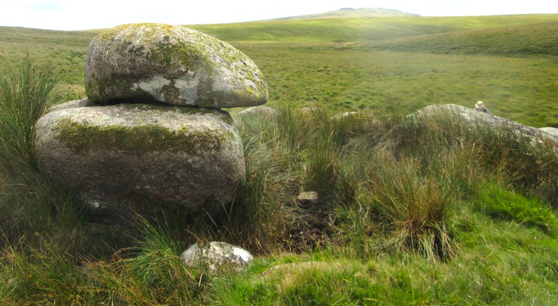 Given its isolated location Walkham Rocks feels like a place that is rarely visited and is most certainly off most of the beaten tracks of Dartmoor. This alone makes it a must see little rockpile.
| ||||||||||||||||||||||||||||||