
A few weeks ago, Tim Jenkinson emailed me a link to an online reference of a long forgotten tor curiously called Nympenhole. It was part of an article about Hameldown and within it, an author, named Sir Walter Besant, described the views from King’s Tor. I tracked down the origins of this and found a fictional tale called “To Call Her Mine”. A bit of further research and I then conveyed my thoughts of a possible location to Tim, they coincided with his suspicions. We decided that, even though the book was fiction, it was still well worth a look. First opportunity to meet up, we set off from the car park in Manaton, excited to go in search of a lost tor.

The paragraph that piqued Tim’s interest; “On the north-east is Ease Down, with its long slopes, and the granite pile upon its highest point; and below Ease Down, Manaton Tor; above the church, and below Manaton, a spur runs out between the valleys, and there are Latchell Tor, Nympenhole, and the Ridge.”
Using this, Tim was able to rediscover Latchell Tor many years ago, within the Letchole Plantation. Nympenhole, however, proved elusive. The main issue is that most of the land from Water along to Houndtor Ridge is inaccessible to the public.

Leaving the road near the Kestor Inn, we took a bridlepath around the back of the cottages of Freeland, where the woodland plantation rises up. Latchell Tor is not hard to find. It is a wide sprawling tor across the side of the hill. It is easily accessible, with plenty of footfall through the area. This tor definitely needs a visit in the winter months, when the scale of granite will be better admired.

From Latchell Tor, we joined a footpath to Water. A few walks back I had found a large logan stone in a field beside a track marked on the map. I offered it as an alternative to the Water Rock described by William Crossing and later rediscovered by Tim. As it was on private land, there may have been a chance that Crossing had never even encountered it. To read further follow this link.
I should point out that it is always better to seek landowner permission when on private land. On this occasion, we were on a marked track and saw no “Private” or “Keep Out” signs to deter us.

Surrounded by foliage, it was hard to see the rock in all its majesty, sat on its granite plinth, but it was still a good find and one I was quite proud of.
Now we turned our attention to Nympenhole; plotting a rough sight line on a map, from King’s Tor to Latchell and further to the ridge (which is obviously Houndtor Ridge), narrows down its location.
I had also found, online, that the book had been serialised in a newspaper called the Palace Journal, This began in 1886 with the purpose of providing an educational and cultural centre for London’s east end community. An archive can be found on the Queen Mary University of London Archives. Our section of interest was published on 16 January 1889.
Within, it revealed a further mention of Nympenhole, when describing the location of a house called Gratnor. “.. Beyond the stream the ground rises steeply. This is the slope of Oddy Tor, by some called Nympenhole and by others Viper Tor. It is clothed with thick woods, dark and impenetrable, which hide the moss grown boulders on the top.”
Of course, this was fiction and there was every likelihood that Gratnor only existed within the book so I checked both the 1881 and 1891 census to confirm there was no house of that name in the area. I expected that outcome, but as the author had used actual names of other places on Dartmoor, there was every chance that the surroundings were very real and our lost tor existed.
Then a further paragraph went on to describe: “A gate opens to a lane which leads to the green through the hamlet of Watercourt, past the little chapel… The lane also passes the smithy, where Harry Rabjahns and his two ‘prentices all day long blow the bellows and beat the anvil.”
Watercourt, matches Water. From this and Tim’s recollection of looking at a parcel of land from its boundary, we had a fair idea now where we needed to look.

Back to the walk; we went on along the track, reaching another outcrop at a corner of three field boundary walls. It was a good outcrop, but Tim had a sixth sense that there was something better around here.
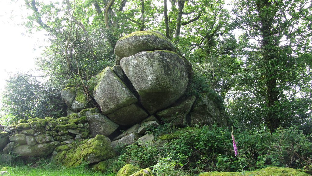
We came to our prize a few minutes later, exactly where we had expected it to be! We were certain we had found the tor mentioned by Sir Walter Besant; “Oddy Tor, by some called Nympenhole and by others Viper Tor“. A later look at Tithe maps shows that this is on a plot of land called “Ripintor”.

It is a collection of summit outcrops, the largest straddling a boundary wall. It is surrounded by trees making it invisible from accessible land, but it looks as though the “dark and impenetrable” woods had been thinned somewhat.


Later that weekend, I found a further entry in the book that, I feel, confirms this was the correct location; “Standing on Hayne Down, over against the ridge one can see how the ground breaks down, with hill after hill, each lower than the other, until the Ridge itself abruptly falls into the lower Coombe at Riddy Rock, where the waters meet. First, there is Ease Down; then, Manatton Tor; next Latchell; and lastly Nympenhole, or Oddy Tor..“

Pleased with our morning’s work, we returned to the security of a public footpath and went to check out the place where Tim had previously been. Standing at the gate, looking into the field, it confirmed that Oddy Tor had been but a stones throw away.
UPDATE 04/11/2018
A look at the Tithe Map for Manaton has revealed two plots of land; “No. 686 – Higher Nympkinhole” and “No. 689 – Lower Nympkinhole” sitting below another tor, discovered by Tim Jenkinson, called Water Cleave Tor at SX 716 814.
Beside these two plots of land is another called “No. 684 – Grattner Moor”.
So, whilst Sir Walter Besant’s descriptions do not fit with the Tithe location, it is likely that Water Cleave is the inspiration for the tor in his book but we must also consider that perhaps the name “Nympenhole” was taken and some artistic licence was applied to the locality. If it is our error in interpretation, how odd (or Oddy even) is it that his text led us straight to this other tor which we now know as Ripin Tor? If it is our error, I, for one, am glad because we may never have discovered it.