
An edited version of this article appeared in Dartmoor Magazine – Autumn 2017 Issue 128.
Having previously written in this series about some of the interesting and lesser-known aspects of East Dart River to the north of Dartmeet (DM121 winter 2015 pp40–1), this article (and the one to follow) concentrates on the same river, but this time along a picturesque stretch to the north of Postbridge as far as East Dart Falls. Rather than just providing a description of a walk along the riverbank here, both articles are instead more of a commentary on some of the interesting things to see and so therefore do not require a single visit but allow for inspection at leisure whenever in the area.
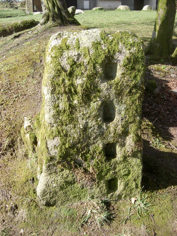
The starting point is the car park at Postbridge (SX 646788), where two fine examples of slotted granite gateposts stand. Richard Hansford Worth (1953 pp361–7) provides a comprehensive review of the various types of gatepost in his book Dartmoor. From consulting his guide, it seems that the two posts in the car park are what he terms ‘Slot-and-L Gates’, one with four oval holes each of approximately 4.45cm in depth facing the other post which has four inverted ‘L’-shaped notches, the latter enabling bars or poles to be fixed in place in the downward vertical slot of the L. Many of the older and now chiefly redundant slotted gateposts of varying designs continue to survive on Dartmoor near to the farmsteads where they were once used.
Leaving the car park, the footpath to Hartyland is the preferred route in the first instance, proceeding from the northeast end of the road bridge and then heading northwards across what in winter months is rather boggy ground. Sadly, the path here, although clearly marked on maps, has somewhat deteriorated in recent times and care must now be taken to negotiate what has become a rather difficult muddy track which in places is ill defined. On nearing the wall, a turn to the west is necessitated, and then getting through the gate beside the river to the southwest of the house is the aim. From here the next point of interest will be the William Donaghy memorial rock on the lower northwest slopes of Hartland Tor. Again, the tracks here are rather muddy and worn, and care must be taken when ascending the tor.
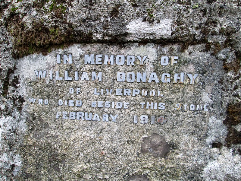
Regarding the memorial we learn from Simon Dell (2014) that Mr Donaghy came from Liverpool and had worked as a science master at Warrington College. He apparently passed away in February 1914 beneath the very same rock that now bears a small inscription to that effect. The large boulder is quite difficult to find as there is now an excess of gorse in the area, but the grid reference of SX 6399 8007 should assist in its location which is about 70 metres to the south of a large holly tree.
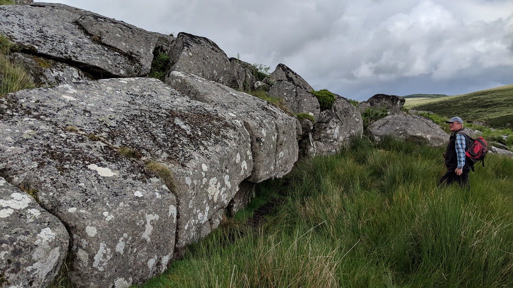
Climbing the slope and continuing northwards towards the walls of the Stannon Newtake, the magnificent Scotch Sheepfold comes into view on the slopes under Stannon Tor to the east. Soon thereafter a ruined tor can be seen high on the west side of the river set low down under the eastern side of the giant Broad Down. Here there is a huge spread of broken granite with no apparent summit it stretches for some 250 metres or so above the riverbank. The largest flattened outcrops are on the southern edge of the rock field at SX 6380 8080, whereas a small and rather beleaguered pile stands to the north at SX 6370 8100 a few paces below a ruined cairn that is marked on the map. There is a huge, impressive boulder that seems to have toppled from the hillside standing much nearer to the river above a section of disused leat at SX 6390 8110. Strangely, given the expanse of granite here, there appears to be no reference to these rocks in the literature.
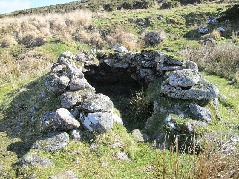
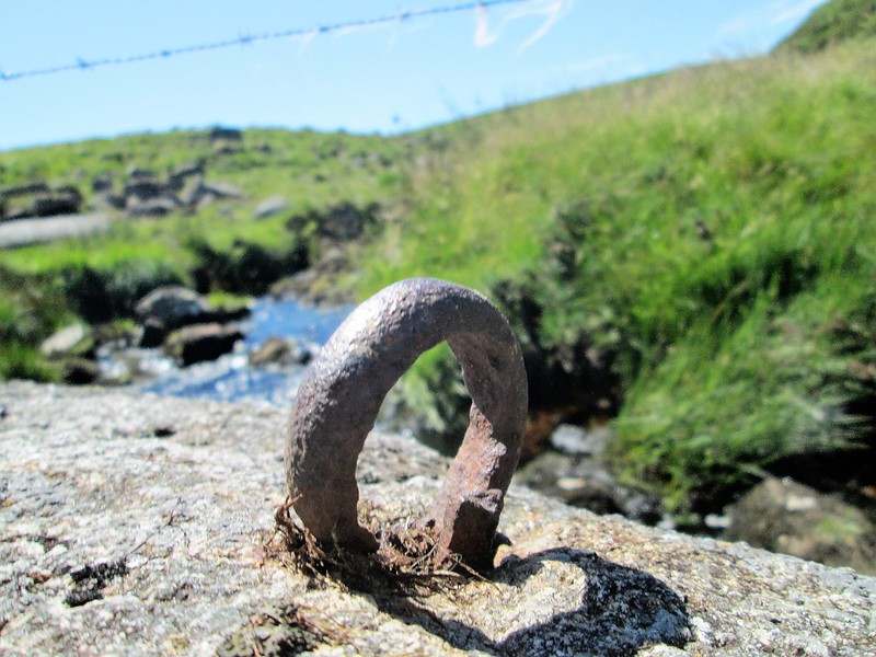
The next point of interest is the well-known beehive hut just to the north of the main river at SX 6393 8145. This well-preserved but curious little ruin has a rounded appearance with a low doorway and has been roofless for many decades now. Eric Hemery (1983) advises that these huts were probably constructed by medieval tin workers and were largely used for the purpose of concealing tools and ingots. From here, and following the river upstream in a westward direction, the visitor enters one of the most picturesque aspects of the watercourse. Nearby at SX 6365 8135 beside a wooden stile at the point where the wall from Lade Hill meets the river there are at least four curious iron rings set into rocks. Usually these were placed for the tethering of horses, but these artefacts, one set in the river itself (see photo), are far too close to the water for achieving that, so instead they look to have been involved at some point in supporting a wire fence, perhaps to discourage cattle from coming downstream. Indeed, a piece of barbed wire is still stretched across the river here to achieve this.
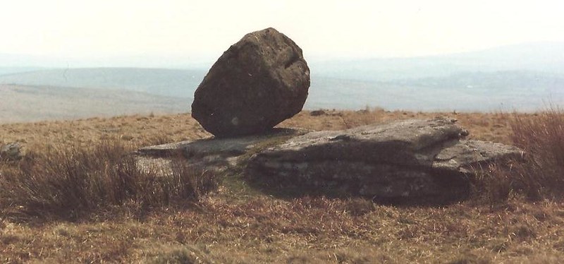
Above and well to the northwest lies the huge whaleback of the aforementioned Lade Hill, that on its south side has several low outcrops dotted across its slopes, including near the summit a curious rounded logan-type rock that is perched on a flat outcrop at SX 6328 8179. While both Crossing (1912) and Hemery (1983) refer to the hill and nearby Lade Hill Brook, Bottom and Marsh, still to this day these names do not appear on Ordnance Survey (OS) maps. In his book Dartmoor Worker Crossing (1992) explains that the word ‘Lade’ refers to a ‘ditch or drain’ which ‘leads water’ and is derived ‘from the Anglo-Saxon “lad”, a canal or conduit and is indeed only another form of “leat”’, the hill thereby taking its name from the leat that is said to have once conveyed water from Sandy Hole on the East Dart for some 3 1/2 miles to the Vitifer Mine at the head of the West Webburn river. The crown of Lade Hill is crossed by a sturdy newtake wall which runs to and through Sittaford Tor to the north. The views from here are spectacular, especially to the south where on a clear day the many tors of South Dartmoor are visible. Well worth a visit.
The next article will complete the exploration of this part of East Dart Country and will examine another nameless tor, the curiosity of the Winney’s Down logan rock, the East Dart Falls, look at outcrops on Broad Down and the well-preserved Roundy Park kistvaen that is just off Drift Lane.
References
Crossing, W. (1912) Guide to Dartmoor Reprinted 1990 Peninsula Press
Crossing, W. (1992) Dartmoor Worker Peninsula Press
Dell, S. (2014) Dartmoor Curiosities Dartmoor Magazine 115 Summer
Hemery, E. (1983) High Dartmoor: Its land and people Hale & Son, London
Worth Hansford, R. (1953) Dartmoor 1994 edition Peninsula Press