
An edited version of this article appeared in Dartmoor Magazine – Autumn 2021 Issue 143.
This article details a short excursion over parts of Harford Moor with a starting point at Harford Moor Gate (SX 6432 5954). Firstly, we head south towards the picturesque Butter Brook, where we start with the impressive hut circles at SX 6444 5927. These are a scheduled monument first listed by Historic England (HE) in October 1991. The settlement here is described as ‘a well-preserved example of an unenclosed stone hut circle settlement; the hut circles have distinctive orthostatic entrances and wall-construction’.
Sited in a sheltered spot to take advantage of the source of fresh water provided by the Brook, the antiquities are said to ‘provide exceptional evidence of how early farming and stock-rearing communities lived on the Moor’. Consisting of nine distinct hut circles set on a gentle, south-facing slope, dimensions for the huts range from 10 metres to 13 metres in diameter, with walls up to 2 m. thick and a metre high, faced with upright stones on both sides. They are described as having entrances that are usually framed by distinct orthostatic jambs that face to the south-east. Some of the hut circles are set into the slope. In his account of the area Jeremy Butler (1993) explains that a number of the Bronze Age huts were destroyed during the construction of the nearby and now disused Butter Brook reservoir. HE give the details that unfortunately a group of huts lying within what is now the reservoir plantation was destroyed by the construction work of 1914; and that at one time collectively these may have all formed a single group.
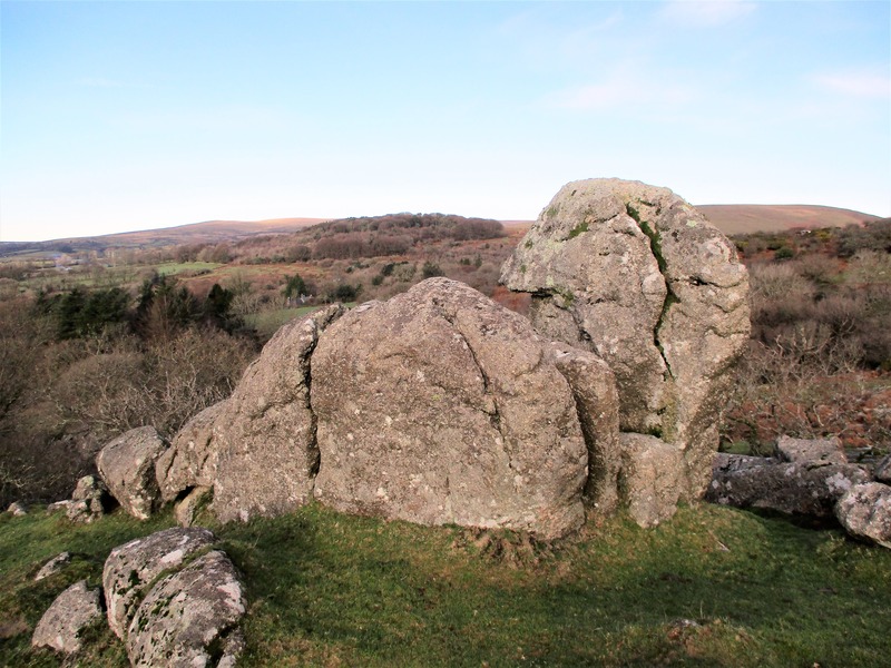
Crossing Butter Brook and heading downstream, on the left the substantial sprawl of granite known as Tor Rocks soon appears. This secluded and part shattered tor at SX 6411 5913 lies a mere 350 metres or so to the south-west of the Moor Gate. Apart from a few scattered large boulders, unusually the main rocks are not visible from any part of the moor to the north or east but upon descending Butter Brook the fascinating tor remnant is revealed. William Crossing (1912) was equally impressed first describing the Rocks ‘as a very interesting pile’ and later as one that ‘the rambler should visit’. Hemery (1983) uses even more superlatives calling it ‘an extraordinary pile’.
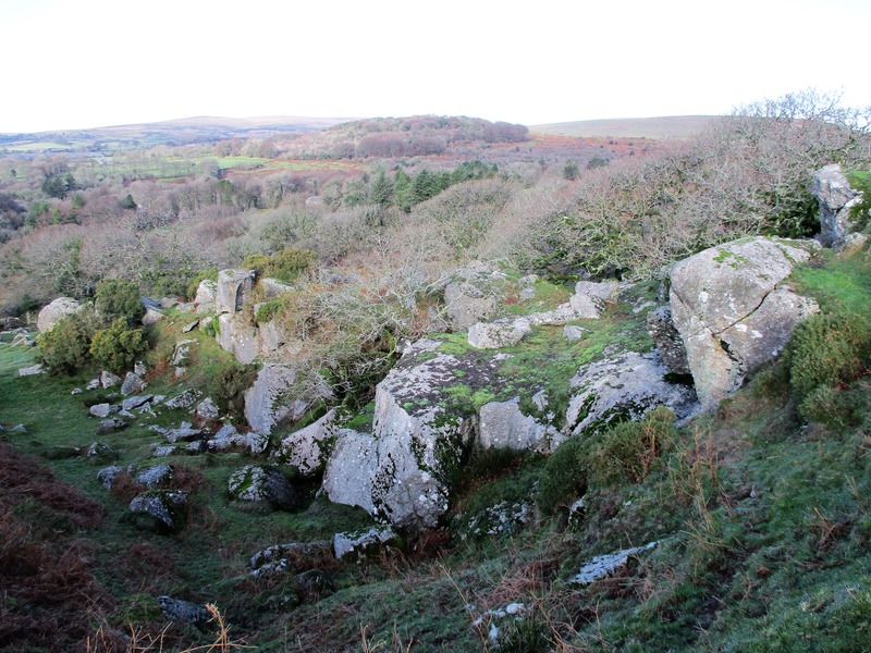
Set above the south bank of the brook the granite here has been plundered with a huge excavation in the side of the hill. This was reported upon in the Western Morning News of July 1861 with a somewhat scathing account about the Duchy of Cornwall’s role in moorland management upon the proposed closure of the nearby Butterdon (Harford Moor) Rifle Range: ‘Beyond once a year coming down on Harford Moor to search for bullocks, the Duchy have never exercised any rights or committed any acts of ownership until about five years since, when, alleging that the moor was theirs, they granted permission to a company to open a granite quarry, by which Torr Rocks, a valuable and interesting monument of antiquity, was destroyed’.
This therefore dates the quarry at Tor Rocks, which is still marked by that name but as shown as ‘disused’ on modern OS maps, to about 1856. Whilst the rockpile is not entirely ‘destroyed’ it has certainly suffered, but still retains some interesting features. For example, near the summit there is a curious rock formation that from certain angles resembles a parrot’s head. Some of the outcrops on the north side are considerable and it is a most sheltered and picturesque spot beside the brook that flows beneath. Higher up the slope though, the true extent of the quarrying is revealed and indeed there has been considerable disturbance to the tor’s substance. The main quarry is large and has been gouged into the very heart of the rocks the ruin here a sobering reminder of how the desire to cut granite out of the hillside for use as a building stone completely overtook parts of the Dartmoor landscape in the mid-19th Century. That said views from the top of the quarry are especially good.
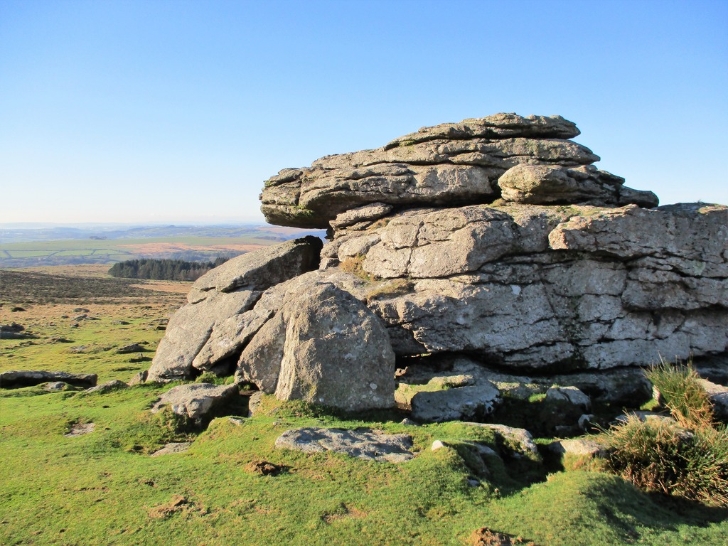
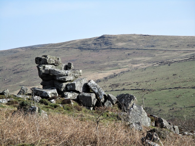
Climbing away from Tor Rocks to the east we now head for a prominent outcrop on the horizon this being Hangershell Rock at SX 6549 5936. This is a most impressive tor remnant that according to Hemery was also known by the name of Hanger’s Shiel and Hangershill. This evocative description appears on the Tors of Dartmoor website ‘The tor takes on different forms as you round it and has cast a substantial clitter that is flung down the western slope of the hill across the Redlake Tramway towards the now disused small reservoir at Butter Brook. Trees find refuge in this clitter that is amplified by gorse flowers. The summit of Hangershell Rock reveals small, pitted rock basins that provide a perch from which to enjoy the thrilling vista of Hanger Down Clump and the southern heights, and most notably Stall Down and Sharp Tor to the north that oppose one another above the River Erme’.
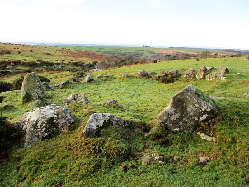
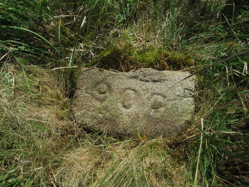
Not far from the main rock and set flat in the ground is one of the small oblong granite range markers that survive from the aforementioned Butterdon Rifle Range. This particular one is inscribed with the number ‘900’ to signify a distance of that many yards from a target and is significant in so much that it is within the range of the long Enfield Rifle that was in use at that time. Opening in May 1861 the Range had a short life and was closed not long thereafter in July following complaints of encroachment from Ugborough onto Harford Moor.
Recent surveys of the area covered by the Range, first in 2014 by Nigel Stainer and again in 2016/17 by Mark Fenlon and myself, both inspections inspired by the earlier work of Dave Brewer in 1996, have revealed the continuing existence of 102 such markers that are embedded in the gorse and grass fanning to the north and west of Hangershell Rock. Set at 50-yard intervals to a maximum of 900 yards in four of the eight lanes they are remarkable artefacts from the Victorian era (Fenlon and Jenkinson 2021).
North of the old Range is a wide grass track that needs to be followed in a westerly direction across the head of Butter Brook and soon before us beyond newtake walls further to the west we get a view of Tristis Rock (SX 6384 6016) on Burford Down that is also given the name of Hall Tor by William Crossing and Cuckoo Rock by Eric Hemery. It is an impressive rockpile that can be viewed in much closer detail by walking down the road from Harford over the bridge and going through the second gate on the righthand side and then following the path in an upward and northerly direction parallel to the boundary wall of Hall’s Plantation until reaching another gate whereupon the rockpile is visible to the right. A path is traceable towards the tor that consists of two main outcrops the higher being the biggest but the lower the most interesting presenting as a small stack with tremendous views across the River Erme to Sharp Tor. There is also a sizeable clitter scattered across the south east slope.
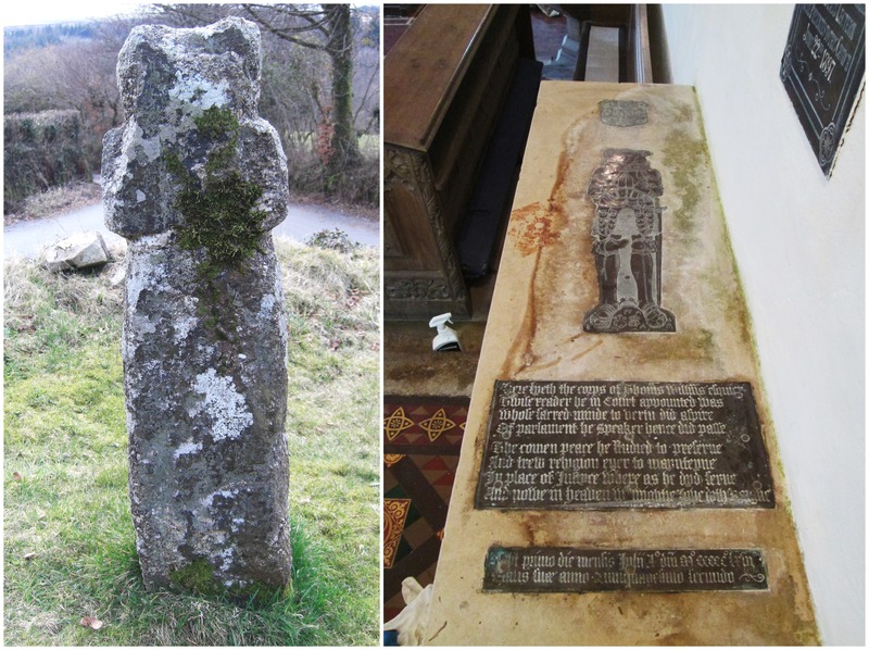
Having completed the moorland excursion a visit to Harford would not be complete without taking some time to explore the village church of St Petroc. In the churchyard there is the ancient Harford Cross and inside the church if access is permitted, is the tomb and brass effigy of the once Speaker of the House of Commons Thomas Williams of 1563. The church itself is described in the Pilgrim’s Guide (2008) as a ‘small, simple moorland granite church dating from the 15th century’ it was restored in 1880 and again in 1921 and is Grade I listed.
Please be warned that at the time of writing in the middle of 2021 during the Covid 19 restrictions, access to the parking area at Harford Moor Gate has been curtailed presumably to discourage visitors and prevent further erosion at the site. This will need checking before exploring the various aspects described here but they can still be reached from other points of the southern boundary that will simply require some extra legwork.
References
Brewer, D. (1996) Dartmoor Magazine, Issue 45, Winter: The Butterdon Rifle Range, pp10-11.
Butler, J. (1993) Dartmoor Atlas of Antiquities Volume Four: The South East Devon Books
Crossing, W. (1912) Guide to Dartmoor 1990 edition Pensinsula Press Newton Abbot
Fenlon, M. and Jenkinson, T. (2021) Dartmoor News, Issue 178, Apr/Jun: Dartmoor Inscribed Stones Revisited – Butterdon (Butter Brook) Rifle Range
Hemery, E. (1983) High Dartmoor: Land and People Robert Hale London
Historic England: Unenclosed stone hut circle settlement west of Butter Brook Reservoir – List Entry Number: 1013210
Stainer, N. (2014): An Archaeological Assessment of the Victorian Military Rifle Range at Butter Brook, Dartmoor. HER SDV357635
The Pilgrim’s Guide to Devon’s Churches (2008) Cloister Books Exeter
Tors of Dartmoor (2021) www.torsofdartmoor.co.uk accessed March 10th 2021
Western Morning News ‘The Camp at Harford’ 19th July 1861